


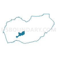
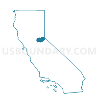
Voting District 20120, El Dorado County, California
About
Outline

Summary
| Unique Area Identifier | 529968 |
| Name | Voting District 20120 |
| County | El Dorado County |
| State | California |
| Area (square miles) | 35.37 |
| Land Area (square miles) | 35.37 |
| Water Area (square miles) | 0.00 |
| % of Land Area | 100.00 |
| % of Water Area | 0.00 |
| Latitude of the Internal Point | 38.68135100 |
| Longtitude of the Internal Point | -120.69514710 |
Maps

Graphs
Select a template below for downloading or customizing gragh for Voting District 20120, El Dorado County, California


Neighbors
Neighoring Voting District (by Name) Neighboring Voting District on the Map
- Voting District 20085, El Dorado County, CA
- Voting District 20105, El Dorado County, CA
- Voting District 20150, El Dorado County, CA
- Voting District 20160, El Dorado County, CA
- Voting District 20165, El Dorado County, CA
- Voting District 30191, El Dorado County, CA
- Voting District 30195, El Dorado County, CA
- Voting District 30215, El Dorado County, CA
- Voting District 30235, El Dorado County, CA
Top 10 Neighboring County Subdivision (by Population) Neighboring County Subdivision on the Map
- South El Dorado CCD, El Dorado County, CA (102,407)
- North El Dorado CCD, El Dorado County, CA (31,207)
- Placerville CCD, El Dorado County, CA (16,716)
Top 10 Neighboring Elementary School District (by Population) Neighboring Elementary School District on the Map
- Mother Lode Union Elementary School District, CA (15,401)
- Placerville Union Elementary School District, CA (15,279)
- Pollock Pines Elementary School District, CA (8,777)
- Gold Oak Union Elementary School District, CA (8,334)
- Pioneer Union Elementary School District, CA (5,393)
Top 10 Neighboring Secondary School District (by Population) Neighboring Secondary School District on the Map
Top 10 Neighboring State Legislative District Lower Chamber (by Population) Neighboring State Legislative District Lower Chamber on the Map
Top 10 Neighboring State Legislative District Upper Chamber (by Population) Neighboring State Legislative District Upper Chamber on the Map
Top 10 Neighboring 111th Congressional District (by Population) Neighboring 111th Congressional District on the Map
Top 10 Neighboring Census Tract (by Population) Neighboring Census Tract on the Map
- Census Tract 315.02, El Dorado County, CA (6,031)
- Census Tract 314.02, El Dorado County, CA (5,896)
- Census Tract 314.06, El Dorado County, CA (5,544)
- Census Tract 315.04, El Dorado County, CA (5,337)
- Census Tract 312, El Dorado County, CA (5,193)
- Census Tract 313.01, El Dorado County, CA (3,408)
- Census Tract 315.03, El Dorado County, CA (2,810)
- Census Tract 314.05, El Dorado County, CA (2,426)
- Census Tract 314.04, El Dorado County, CA (2,407)